A Delineation of the Strata
Article on Rodney Harris’s A Delineation of the Strata of England and Wales, with part of Scotland, Ireland, France for the Autumn 2017 issue of Printmaking Today.
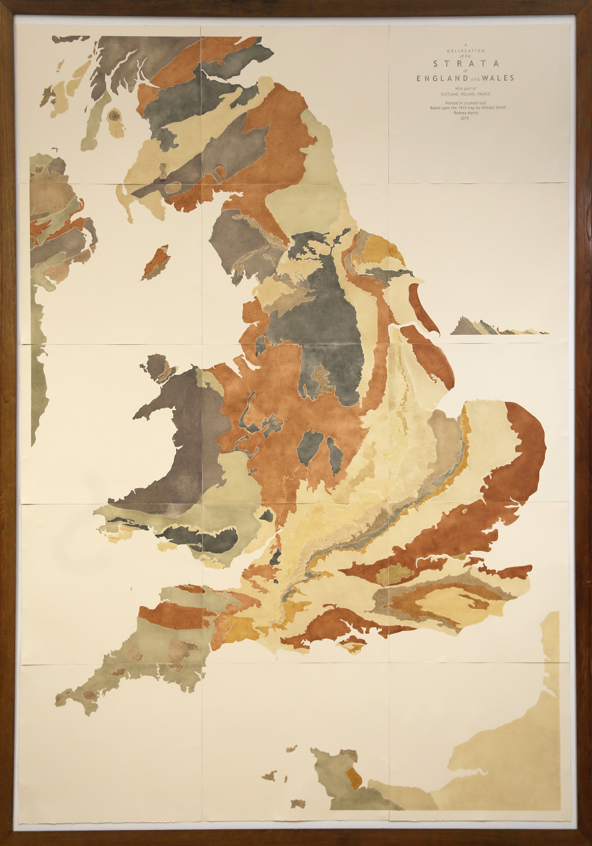
Rodney Harris’s A Delineation of the Strata of England and Wales, with part of Scotland, Ireland, France is a 15-part print based on the first geological map of England, Wales and southern Scotland, made by William Smith in 1815. While Smith’s map is a rainbow of hand-tinted gradients, his vivid colours exaggerate the hues he found in the rock strata and in some cases, invent them: for instance, chalk is represented by green ink. Two hundred years on, Harris has reworked that map with a concise gesture that brings us closer to the land we inhabit.
The pigments in Harris’s print are made from rock, collected by him from all of the areas depicted in Smith’s original map, then ground and mixed with linseed oil to form a printable ink. Harris, who is primarily a sculptor, describes this process in a Serra-like list (1): walking, searching, collecting, drying, smashing, grinding, sieving, mixing, rolling, printing; physical actions that result in ‘discovering’ the colours that appear on the paper.
Harris’s map not only presents us with the true colours of the earth, but is more truthful than Smith’s in temporal terms. While we tend to view land as hard and permanent, in reality it is constantly, if imperceptibly, changing. By collecting his raw material from the ground, Harris uncovers this deception, often encountering rock that is soft and easily ground by hand. In transforming rock into pigment, its solidity and opacity become tentative, the translucent printed ink seeming to question the stability of the substance it originated from.
The white cliffs of Dover, glowing through frequent greyness, are purportedly symbolic of permanence, continuity and independence. They are often saluted as our natural wall: geological matter as middle finger to mainland Europe. Yet to walk along the top of a chalk coastal cliff is to observe its ragged edges, frayed like torn cotton. Creep close to its perpendicular and peer down, to see sprinkled white nuggets in the sand below, like lumps of flour that could be plucked from the beach and pulverised between finger and thumb. Occasionally Dover’s soft, permeable façade experiences a headline-grabbing landslide, but most of the time it regardlessly continues its inexorable crumble into la Manche.
Walking deepens our connection to place, but few people understand land as well as those who work with it and on it. Harris is from a Somerset farming family and attributes his profound bond with that landscape to his agricultural background. The simple act of digging reveals what is beneath, beyond that which the eye sees, and by booting a spade into soil it is possible to literally cut through time, through its accumulated layers.
Clay, mud and stone are the most fundamental materials that humans have used to build, make objects and paint with. Readily available and associated with a primitive past, they are regarded as useful but not precious. In contrast, considering the use of ultramarine in religious painting, a colour first produced from lapis lazuli in the twelfth century, Maggie Nelson writes: ‘[It] is not, of course, holy in and of itself. (What is?) It had to be made holy, by the wicked logic that renders the expensive sacred.’ (2)
Gold, silver and bronze indicate a familiar order of merit, while wedding anniversaries illustrate our tendency to categorise materials according to a hierarchical scale of value. While early anniversaries are marked by paper, cotton, leather, linen and wood, longevity in marriage – assumed, culturally, to be an achievement – is rewarded with precious stones and metals: rubies, diamonds and platinum. Monetary value directly relates to accumulated time together.
The human lifespan provides a frame for systematically marking time’s passing with materials that in many cases will outlive us. In this act of measurement matter becomes more solid as the end of life approaches; reassurance is sought in the face of the fundamental impermanence of all things human.
In comparison with the sneeze of a human lifetime, the slow shifts of geological progress offer a sense of calm in their infiniteness. While Google Earth and Street View allow us to see like satellites and walk virtual paths, Harris’s print ventures beyond the notion of contemporary mapping as an accurate, minute representation of surface landscape in the present. With the majority of the world’s population now living in urban areas, our psychological connection to land is increasingly compromised by concrete. The mineral tones of Harris’s map shimmer with emotional resonance, quietly reminding us that our most precious asset – and the one that requires the most protection – is Earth.
(1) Richard Serra, Verb List, 1967–68, graphite on paper, 254 x 203mm.
(2) Maggie Nelson, Bluets,2009. Seattle and New York: Wave Books.
Image: Rodney Harris, A Delineation of the Strata of England and Wales, with part of Scotland, Ireland, France, natural rock pigment on Somerset paper, 3.5m x 1.8m. Courtesy of Bristol University permanent collection. Photo: the artist.